So for Easter weekend I was racing around Pitlochry Scotland. It was a 4 day event. The first day was in Livingston for a sprint. The next day was a long for me on Dunalastair map. The third day was on Craig-a-Barns map and that was a middle. The last day was a relay event on the Newtyle map. Most of the terrain over the 4 days is the same. Wet, lots of rolling hills and rocks!
The first day was alright. We drove all the way up from Durham, England to Livingston, Scotland. I was run in W20E. I didn't make any mistakes I just took it slow because for me messing up or getting lost on a sprint is a very bad Idea. There was lots of underpasses and little alleyways that could easily be missed. You needed to know the direction you were leaving the control. You also had to really read ahead and have a route planned because there were a lot of traps.
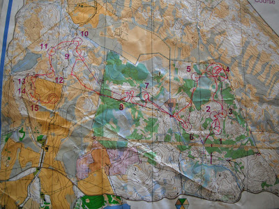
The next day on my long it didn't go so well. I took way to long trying to find my first control because I thought the scale was 1:7,500 and it was actually 1:15,000. Once I got that sorted it was okay for the next control. Going to number 4 was not good I thought about going one way but decided to go the other way around because I didn't want to go through all the green. I got really lost and kept think oh it is the next knoll. I finally bailed relocated and found it right away. The last third of the course was in a big field and it was really hard to go fast and not sprain your ankles or smash your knees on rocks. I need up smashing my knee on a rock. I finished the race but it was not one of my better ones.
The third day at Craig-a-Barns was great, I was happy with my race. To get to the start was a real warm up. It was about 1.5km to the start and the last 300m was really up hill. By the third day my legs were starting to hurt. I only made one mistake on this race otherwise it was good. There was lots of detail so it was easy to read as you ran. I felt like I could orienteer on this map and actually have a route, attack point and a handrail if I wanted.
The fourth and final day was a relay. It was on Newtyle hill map. My leg was really easy. I just couldn't run up hills. I would try and my legs would say I don't think so. My first control was up a big hill and it was hard on my legs to run up a hill on only the first control. That was the only really big climb. the rest would be just 1-3 contour lines. This map was fun. I would have love to run a more technical leg.
Their banquet dinners are a Ceilidh. It was so much fun to dance with tons of different orienteers. I learned a lot of different dance.
This was the sprint map
My Long at on the Dunalastair map
Middle on Craig-a-Barns
My leg for the relay on Newtyle map
I finished my Long!
Finish at Craig-a-Barns
One of the mass start for the relay
The Jk was a really fun event and I got to run against the people who are trying for JWOC and WOC. My next event is the BOC long in the lake distract were I am running W20E. 7km here I come!


You are really getting tons of orienteering in. Sounds like lots of fun - even with the rain! Livingston is a new town, isn't it. So the town planning could be weird. Enjoy the Lake District!
ReplyDeleteThat sprint map looks crazy! Sounds like you're having an amazing time. Keep the blog posts coming!
ReplyDeleteThanks for the stories! So much fun to read about all that is going on, and seeing those Team Canada shirts all around the orienteering world.
ReplyDelete