Tuesday, January 8, 2013

World Cup Sprint and Middle

Time for another update from New Zealand. A lot has happened in the past few days!

Sunday was the middle distance, held in a really tricky sand dune area. They started us of with a few straightforward controls in the forest and then straight into the really complicated dunes, where it was hard to even make a plan to find the control! There were some huge mistakes made during this race!

Monday was the sprint qualification, held on the grounds of the New Zealand Parliament in Wellington. It was a very fun, quite tricky (or so we thought) sprint with some good route choices. Unfortunately, we both missed qualifying for the final, with Will on some 20 seconds out.

Tuesday was the sprint final. We were able to watch the World Cup runners first before running the same course ourselves later. It was fantastic to watch Lizzie Ingham finish with a bronze medal in her home city! We were very privileged to run on the grounds of Government House; the organizers said that was a first and probably a last. Although during the race we barely noticed where we were. This was the probably the most physical sprint I've ever done and definitely the one with the toughest route choices. Have a look at the map and think about what you'd do!


credit: worldofo.com
Today we spent resting and visiting Wellington. We're off to Masterton for a long race tomorrow (not a World Cup) and then the chasing start World Cup in Hawke's Bay on Sunday. Stay tuned!

All maps can be found here. 

Friday, January 4, 2013

New Zealand World Cups

It's currently -17 in Moncton, New Brunswick, but Will and I are enjoying the sunny, warm New Zealand summer. Yay for sunshine, fresh corn and strawberries!

We arrived in Auckland on January 1st. I just completely skipped New Year's Eve and went straight from January 30th in California to New Year's Day in New Zealand. We were hosted by the very welcoming Smith Family in Auckland for two days, where we had a chance to explore Auckland's sites and a couple park maps.

On Thursday we found a car and joined forces with Helen Palmer (GB) for the drive to Palmerston North. On the way we stopped at the scenic Lake Taupo for a picnic and a run out to Huka Falls.

Today we went and ran the first public race, which was fantastic open, intricate sand dune terrain. It's very exciting; there are so many really fast orienteers here!

Look for us in the first World Cup middle race on Monday. The first start is 9:30am local time which is 3:30pm EST (on Sunday!).

PS: Our favourite New Zealand road sign so far is when entering the town of Bulls: "Have you herd of Bulls ... A town like no udder"!

Thursday, December 27, 2012

Orienteering and Running in Bangkok

For the last 17 months I have been living halfway around the world in Bangkok, Thailand.  While I have been in Thailand I have had the opportunity to introduce the sport of orienteering to some Thai children aged 6-12.  They were very excited to try a new sport that they had never heard of before.  I made a number of courses around the school yard at the school that I am teaching at.  The students enjoyed the challenge and adventure of finding the controls marked on the map.  However; they needed constant reminders to orient the map because they were often going in the wrong direction.  Maybe the World Orienteering Championships will one day take place in the land of smiles!  Here is the first ISSOM map that I know of in Thailand:


Running racing and training in a foreign place where the temperature rarely drops below 25 degrees Celsius can pose some challenges.  For this reason many of the running races here start at 6:00 am. or earlier when the temperature is a cooler 24-27 degrees Celsius.  Running a race when it is 38 degrees Celsius and 46 with the humidity would not be ideal!  There are many running races here in Bangkok almost every weekend and sometimes 3+ races on a Sunday morning.  To date I have entered 33 races during my time in Asia.  I have entered races of varying size and distance from small 10.5 km. races (which are called a mini marathons here) to large marathons in Bangkok, Phuket and Pattaya, Thailand; Beijing, China; Chuncheon, South Korea and Singapore.  The constant with the races in Thailand are that you get at least one running shirt/singlet, a medal, and lots of food afterwards.  Many of the races here seem like a big deal with VIP only seating areas, nicely decorated awards stages, prize money and trophies.
Besides the heat, running the streets and sidewalks of Bangkok can also pose some other challenges that we would never even think of in Canada.  One of these challenges is running on an empty stomach and running past many food carts and restaurants along the road selling every type of Thai food you can imagine.  If you are hungry then there is the urge to stop and eat some food.  Another challenge is dealing with the odd chilli powder in your eye while you are running.  Chilli powder and spices are very prevalent in Thai cooking, so there has been many times where I have found myself ‘running blind’ because of chillies in my eyes!  The street dogs can also get a little crazy after dark.  It makes you run faster when they are chasing you!
There is a nice park fee of food, chilli powder and street dog challenges.  This place is called the Buddhamonthon Park, which is one of my favourite places here in Bangkok.  It is a good place to run because it is quiet, beautiful and there is some shade!  I can also practice some visualization and pretending that I am orienteering here spiking a control behind a large clump of bamboo shoots.  It would make an awesome venue for the next Park World Tour (PWT) race… 


Happy New Year from Thailand!

Tuesday, December 11, 2012

Winter Training


During the winter, it’s especially important to try and keep your orienteering, both physically and mentally, up to scratch.  Since August, I have been living in Norway, and as Norway is the country of orienteering, I have gotten lots of good practice in so far this fall/winter.  I've had a couple of training sessions that were new to me, so I thought I would share them.

The first thing I got introduced to was orienteering inside.  I've actually done this before, but never on such a large scale, and never as a race.  This can be incredibly fun, and the more the merrier.  For those of you with a college or university nearby, I would suggest this!  The idea is to find a building with as many passages, floors, staircases and dead-ends as possible.  Then, you draw a course with as many floor changes, dead-end controls and traps as possible.  And set everyone loose to get confused and run around in circles!

This is a map of one of the
buildings in the local university

It’s also very important to keep running during the winter, even if you are cross-training with skiing, or some other sport.  Long runs can be amazing.  Maybe chose a map that you haven’t run on in a long time, and just run.  If you live in an area with lots of lakes, maybe do a lake-to-lake run, although be sure to check that the ice is thick enough before you cross! 

A group of orienteerers out for a run

These days, you can start running at 11 and still catch the sun rise!
Those who have little to no snow, like those in Trondheim, can orienteer in the streets all year round.  Running can always be a bit more fun when you have a map to run on!  A recent training session here had us running longer legs, corridor style, with small sprint sections of 4 or 5 controls interspersed.

The point was to run slower on the corridor, and really try to
sprint the large circles.  You could not go outside the blue line.
For those not living in a snow-less climate, mental training is important as well.  Here, while we are doing core workouts, we also armchairs read, or remember what the columns in the control description mean, or choose the fastest route.

From my calculations, the shortest routes are:
1,A:2,A:3,C:4,B:5,C:6,C:7,A:8,C
I may be wrong.
I hope that you all are having a wonderful winter, whether full of snow, or not, and that you all continue to have a good year in terms of training!

Tuesday, December 4, 2012

(8th best) Course of the Year

I’ve always considered myself a good course setter.  I never thought I might end up designing a course that might be in the running for course of the year on World of O though.  Particularly not this year.   And yet that’s what happened when I designed a training course for a friend of mine visiting from Belgium, Yannick Michiels, on Ottawa’s fabled map the Barrens.  I was looking through some of the courses being put forward during the nomination period and discovered, to my surprise, that my training course from a month previous had been nominated. 
When it came time to vote 80+ courses had been nominated.  You could vote for your top 5.  I had a serious look at the set of courses and, being as honest as I could, placed mine in 3rd.  It helps of course that I was working in awesome terrain but I knew, based on the fact that the course already had something like 800 views on WorldofO, that my course actually some merit. 
My top 5 choices for course of the year.

My course ended up finishing 8th.  I guess that makes me a better course setter than orienteer (FootO World Ranking is 309th)!  Regardless I think the result is super cool.  Here’s some insight into my course setting process (you can find the entire course with Yannick's route here):
The Barrens is an amazing area for technical middle distance orienteering but the layout of its abundant lakes also allow for great challenging longer route choice legs.  Yannick had asked me for some middle distance type training lasting around an hour in length.  Perfect. 
I’ve raced and trained on the Barrens a good half a dozen times in since its debut at the Canadian Champs in 2010 so I know the area pretty well – something that important when course setting for training where there won’t be anything at the controls.  I felt comfortable in being able to pick out which features would be obvious enough to use as control circles just by looking at the map and I knew which areas were most interesting. 
That’s the ground work.  There’s only one real access road so that partially takes care of the start and finish variable.  I chose the same start location as for the Ottawa O-Fest 2011 long – it’s easily accessible from the road and provides a good bit of interesting technical orienteering right from the start.  For training the finish generally goes right by the start – in this case I had no reason not to so that’s what I did. 

Given the terrain I split legs into technical and route choice categories (with transport legs to get from one section of the course to another as needed) before even starting course setting. 
I wanted to start the course off with some short legs to get Yannick into the unique terrain.  At that point a route choice presented itself.  The route choice isn’t extreme but the straight route that Yannick took (probably fastest) is still somewhat technical.  The terrain around 4 opens up a bit so I can take the opportunity to set some slightly longer technical legs where it becomes tempting to go straight and speed up bit.  Dangerous though.  While tempting that is risking disaster in this terrain where it’s easy to get pushed around by the forest, end up in the wrong clearing, and spend a long time re-orienting. 
The next section of terrain shown below is among my favourite anywhere and certainly on the Barrens.  It’s fast and the features are very well defined.  With a little bit of care you can spike controls in there at full speed.  I knew from the start that I wanted to take my course in here. 

The trick here was to set a few short legs with the controls tucked on the far side of features.  I set legs 8 and 9 such that there were one or two larger features in the middle of the leg but lots of detail in the area that could be simplified out.  Change in direction was also important and I’ve set control 8 the way I did so that you come around the cliff to find it but have to go around another corner to get to 9 – you can’t just leave directly on a compass bearing. 
Leg 10 is mostly a transport leg – it’s tricky but it doesn’t emphasize route choice or technical difficulty in any particular way.  I tried in this case to provide some route choice where you can go straight without too much difficulty but you have to navigate carefully or you can head left to the long strip of field heading north west in the direction of the control and then run along then either left around the large marsh before the control at full speed along the clearings or stay right for a shorter but slower entrance.  I’m not sure it worked – I think straight was easily the faster choice.


With controls 11, 12, and the first half of 13, the primary purpose of the legs is to emphasize a unique aspect of the terrain.  The orienteering in this section is all about weaving through the terrain from open spot to open spot, around the lakes, and some of the hills and cliffs – micro route choice can make a big difference here!
Legs 14 through 16 are quite technical but their primary goal is to set up the first real route choice of the course. 
Going left I see 2 options for the first half and 2 options for the second half for a total of 4 options that way.  I see another two fairly equivalent options on the right.  I haven’t run this particular leg and have no idea which would be the fastest.  What would you do?
The next few legs are more transport legs (again difficult in their own right) to get to the more open east side of the map and to set up the next and final route choice.  In hindsight, I could have made one of those much better. 
Here is leg 20 as it was initially:

It’s pretty obvious you go left pick you’re through the little lakes.  With a bit of a revision it could be a very difficult route choice.  Here’s a new version of it:


Here are the last few controls. 

I have never actually visited the particular feature at control 21 but it’s nice forest around there and the feature is unique in that it’s mapped in grey instead of in yellow even though a lot of the rest of the yellow is mostly open rock so I wanted to take Yannick to it.  It’s also a great starting point to a classic left / right route choice.  Because of the layout of the route it becomes very tempting to take the right route choice heading out of control 21 because you’re closer to the line on the first half of the leg. 
I think the following route (dashed purple) is best though because it takes you through a series of long fields connected by white woods along a giant handrail that is nearly impossible to screw up.  The first bit of the leg takes you over ground you’ve already travelled and the last bit is the same regardless of you choose left or right. 

Everyone has a different course setting process and it can vary a lot depending on the terrain.  In this case I already knew the terrain and map quite well so I could sit down and plan this course in under an hour.  As it was training for a single person I wanted to set a good course but I wasn’t too worried about the details so that helped as well.  I didn’t pre-run any of the route choice legs to find out which was the fastest which I probably would have if it was for a major event but again, knowing the terrain, I could still set good long legs based on the map along.  Sure it could have been optimized but so what?  That wasn’t the purpose here.

Tuesday, November 13, 2012

An Urban Rogaine

-->

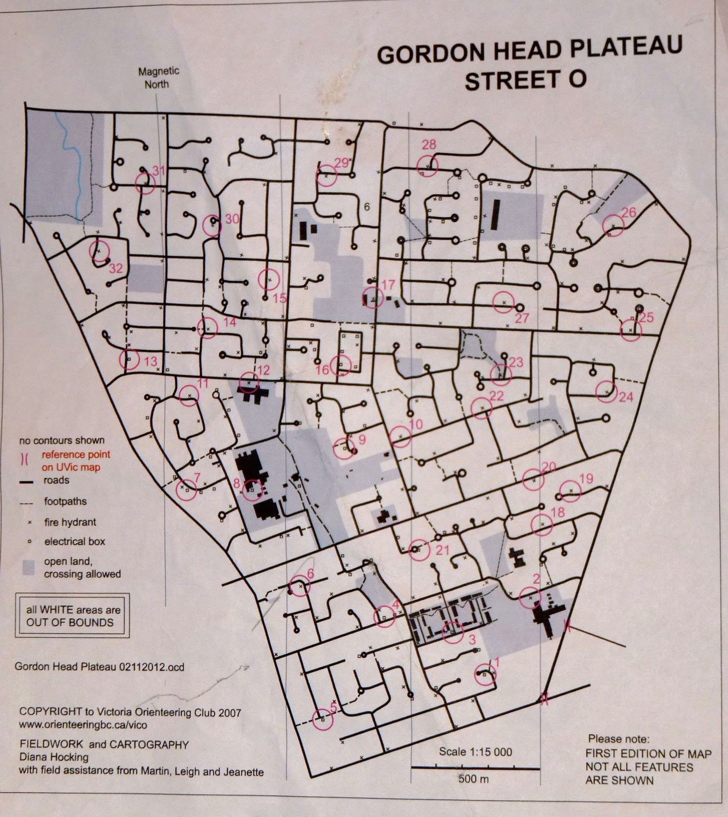
This Saturday I completed my longest orienteering event yet: a 3-hour urban rogaine through the streets of Victoria! It started at the University of Victora, my home campus, and spanned three separate maps: the UVic orienteering map at 1:10 000, and street-O maps of two adjacent neighbourhoods (Gordon Head and 10 Mile Point) at 1:15 000.
The first part and the last part of my route were on the UVic map
Instead of using SI, each participant carried a sheet of questions to be answered at control locations, such as giving the registration number of a fire hydrant, or “When are beach fires permitted?’ (“Not at any time,” according to a sign above the beach access). At times this was frustrating if I had trouble finding an answer, since I am used to big orange flags and a control description saying the exact location. But it was also fun to have different tasks at each control. It was fun to explore some new parts of the neighbourhood too – there are lots of hidden trails and beach accesses throughout 10 Mile Point that I had never been to before. 

The ocean!

It was a gorgeous day: a little chilly but the sun was sparkling off the ocean, and lots of walkers and joggers were out. (At one point I had a middle aged couple ask me if I was volunteering – I guess they saw me making notes – and then try to direct me to the park… I told them I was “racing” and kept going…)

There were 86 controls, of which I got to 49 (compare to the winning score of 56). I didn’t even get to Gordon Head, but I am happy with my race anyway – there were a lot of controls, and a lot of ground to cover! I don’t have a GPS, but according to Google maps, I ran about 21 km. By the end, my body was feeling pretty worn out, but I think as continue to train I will be able to run for longer with more ease and grace. The biggest technical challenge was definitely route choice (and I can always benefit from some route choice practice!). It took some planning ahead on the way out to the point, to decide which central controls I should go to, and which ones to leave for the way back.
Almost got them all!
I'll have to do this part another day :)

I'm looking forward to doing a self-organized rogaine on the Gordon Head map sometime soon. It's nice to be able to train with a map, even a simplified one, and it makes training more exciting!

The results are available from the VicO website: http://www.orienteeringbc.ca/vico/

Monday, November 12, 2012

The 5 Stages of Orienteering Grief

There is no such thing as a perfect race in orienteering. We all make mistakes of varying sizes, but it can be hard to come to grips with them. You may experience denial about your mistakes, anger at the course setter, bargain about what could have been if only… wait this may sound familiar. The five stages of grief, usually applied to major life changes, are: Denial, Anger, Bargaining, Depression, and Acceptance. These stages can occur in any order and be applied to other things, such as sports injuries (for instance, at first we often deny we are injured)! Perhaps a better understanding of these stages can help us deal with our orienteering hang-ups?

While making a mistake orienteering you might deny the error, bargain about still being where you wish you were, be angry with yourself for making a mistake, and be depressed about the amount of time you have lost. The main thing is that to recover in the best possible way from the mistake, and to most effectively continue the rest of the course, you need to accept that you made the mistake.

You may also experience the five stages of orienteering grief after an orienteering race that went south. You might be angry with yourself, the course setter or mapper. You might comb through the splits analyzing how things could have gone better, or be depressed at coming up short of your expectations in the results. Again, you need to get past this so that these thoughts are not bothering you during your next orienteering race. You need to get to the point of acceptance where you have learned what you can from your race but are no longer dwelling on it.

The question is, how best to do this?

For fun, and for further understanding of the 5 stages: a giraffe in quicksand.  

Anyone have any thoughts on this? Sport psychology strategies?